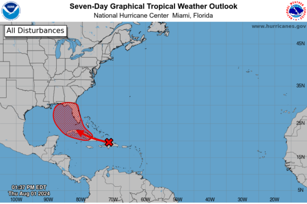
There is a 70 percent chance of a named storm forming over the next week, and a 30 percent chance of it forming in the next 48 hours.
On August 1, Florida Governor Ron DeSantis declared a state of emergency for over 50 counties as forecasters predict a tropical cyclone could impact the state’s panhandle and Gulf Coast in the upcoming week.
The NHC anticipates that the environmental conditions are favorable for the development of a tropical depression, with the possibility of it forming over the Eastern Gulf of Mexico near the Florida Panhandle this weekend or early next week.
If the storm does form, it will be named Tropical Depression, Tropical Storm, or Hurricane Debby.
Reports on August 1 indicate that the storm, known as Invest 97-L, is approaching the Greater Antilles Islands, including Cuba, Hispaniola, Jamaica, and Puerto Rico, at a westward speed of 10–15 knots (approximately 11–17 mph).
Initial models suggest that it will move north off the west coast of Florida and make landfall along the panhandle between the “Big Bend” region and Pensacola.
In preparation for the storm’s potential impact, Governor DeSantis declared a state of emergency for various counties in Florida, encompassing the entire panhandle, Gulf Coast, and northern inland counties.
The declaration outlines possible conditions such as heavy rainfall, flash and coastal flooding, infrastructure damage, and power outages.
The NHC has indicated a 30 percent chance of a tropical depression forming in the next 48 hours and a 70 percent chance within the next seven days.
According to the National Weather Service (NWS), specific criteria must be met for this tropical wave to develop into a tropical depression, tropical storm, or hurricane.
The Florida panhandle has experienced several severe weather events recently, including Hurricane Idalia in 2023 and tornadoes in 2024, highlighting the region’s vulnerability to extreme weather conditions.


