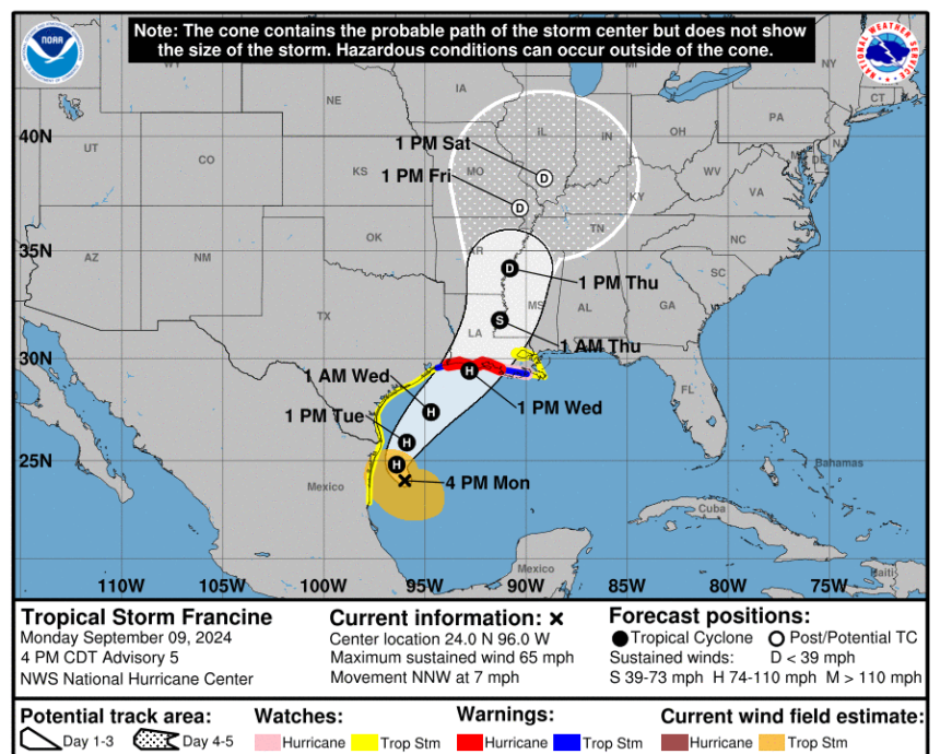
Tropical Storm Francine is projected to become a Category 2 hurricane with maximum sustained winds of 100 miles per hour and is expected to make landfall earlier than previously anticipated in Louisiana. The eye of the storm is forecasted to hit the Rockefeller Wildlife Refuge around 1 p.m. on Sept. 11, moving north-northeast towards the Mississippi River and affecting cities like Lafayette, Lake Charles, Cameron, and Alexandria. The storm is predicted to weaken into a tropical storm within 12 hours of landfall.
In response to the approaching storm, Louisiana Governor Jeff Landry declared a statewide emergency and requested a pre-landfall presidential declaration from FEMA. The state’s Emergency Operations Center has been activated, and the Governor’s Office of Homeland Security and Emergency Preparedness will be on 24-hour emergency response starting on Sept. 10.
The National Hurricane Center has issued hurricane warnings along the Louisiana coastline from Sabine Pass to Morgan City, with tropical storm warnings extending beyond those areas. Storm surge warnings have also been issued for various coastal regions, with projected storm surges ranging from two to ten feet.
In terms of rainfall, Francine is expected to bring four to eight inches of rain, with localized amounts of up to 12 inches across southern Louisiana and Mississippi. Texas Governor Greg Abbott has mobilized state emergency response resources in preparation for the storm, including swift water rescue teams and other emergency personnel.
Both Texas and Louisiana are urging residents to stay prepared and informed, with resources like the “Get a Game Plan” mobile app available to help with emergency planning. Landry and Thibodeaux emphasized the importance of readiness and encouraged downloading the app for essential safety tips and strategies.
If Francine intensifies into a hurricane, it would mark the second hurricane of the season to make landfall on the Texas and Louisiana Gulf Coast, following Hurricane Beryl.


