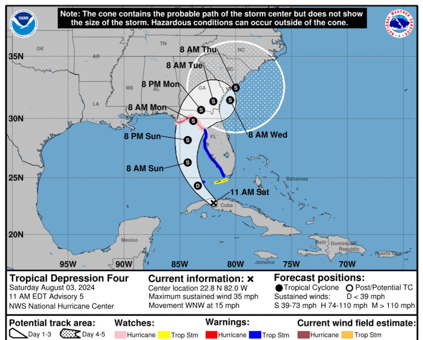
Maximum sustained winds are approaching tropical storm levels.
A hurricane watch has been issued for parts of Florida’s Big Bend and Nature Coast by the National Hurricane Center (NHC) as Tropical Depression Four develops near Cuba and heads towards the Gulf of Mexico.
The NHC’s projected path for the storm, potentially named Tropical Storm Debby, has shifted slightly westward. The gap between the “cone of uncertainty” and the southwest coast of Florida has widened.
However, a tropical storm warning now covers almost the entire west coast of the peninsula from East Cape Sable to Yankeetown, with concerns about storm surge and heavy rainfall increasing.
A hurricane watch is in effect from Yankeetown to the Aucilla River, including areas like Cedar Key, Horseshoe Beach, and Perry. This region was severely impacted by Hurricane Idalia nearly a year ago.
Tropical storm warnings indicate that tropical storm conditions are expected in the warned area within 36 hours. Hurricane watches suggest that hurricane conditions are possible in the area and are typically issued 48 hours before the arrival of tropical storm-force conditions.
A tropical storm is a well-organized cyclone with sustained winds ranging from 39 mph to 73 mph. Once the winds exceed 74 mph, it is classified as a hurricane.
As per the NHC’s 11 a.m. advisory, Tropical Depression Four currently has maximum sustained winds of 35 mph and is anticipated to strengthen into a tropical storm later today.
The maximum sustained winds are predicted to reach 69 mph by early morning on August 5.
The expected rainfall from the tropical cyclone has increased since August 2, from four to eight inches across parts of Florida and the southeastern U.S. coast over the next week, to five to 10 inches, with some areas experiencing up to 15 inches of rainfall.
The NHC’s 11 a.m. advisory also issued a storm surge warning for the area from Aripeka to the mouth of the Aucilla River, with a storm surge watch in place from the Aucilla River to Indian Pass.
Storm surges of two to four feet are anticipated in Tampa Bay, Charlotte Harbor, and the coastal stretch between Bonita Beach and Chassahowitzka, Florida.
Between Chassahowitzka and the Aucilla River, storm surges of three to five feet are expected.
Swells are forecasted to create hazardous conditions along Florida’s Gulf Coast throughout the weekend.

Florida Governor Ron DeSantis declared a state of emergency for over 50 counties on August 1 and expanded the order on August 2 to include seven additional counties, encompassing all Gulf Coast and Panhandle counties.
The governor’s office announced various storm preparation updates on August 2, initiating proactive measures across different sectors from law enforcement to healthcare.
Approximately 3,000 Florida National Guard Members are preparing for response efforts, and the Florida State Guard has activated 70 members for response and recovery assistance, along with deploying nine shallow water vessels, 10 UTVs, two amphibious rescue vehicles, and seven search-and-rescue teams.
The Florida Department of Health is positioning 90 ambulances to aid in emergency evacuations statewide.
The Florida Department of Transportation is collaborating with the Emergency Operations Center to make necessary preparations, including assessing flood risks, securing construction sites, and replenishing fuel supplies.
Attorney General Ashley Moody’s office has activated the Florida price gouging hotline.
Florida’s Division of Emergency Management has elevated the State Emergency Operation Center to level one and is leading coordination efforts.


