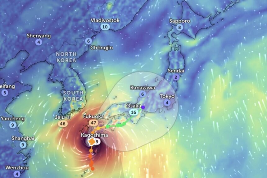
The storm was last measured as a Category 2 Hurricane, with maximum sustained wind speeds of 100 mph.
Approximately 1 million individuals have been relocated as Typhoon Shanshan is expected to hit Japan early on August 29, local time.
Radar data as of 4 p.m. Eastern Time on August 28 indicated the storm’s center approaching the island of Kyushu, just south of Nagasaki. The typhoon is moving at a speed of about 8 mph.
“This is a hazardous system,” warned the Joint Typhoon Warning Center. “Potential risks include destructive winds, heavy rainfall, storm surge, rough seas, mudslides, and flash flooding.”
With maximum sustained wind speeds of 100 mph, it was equivalent to a Category 2 Hurricane on the Saffir-Simpson scale. This marked a slight decrease from the earlier recorded 112 mph, which would have classified it as a Category 3 hurricane.
Nevertheless, wind gusts of up to 114 mph are still being documented.
While its center rotates in the south, Shanshan’s outer bands have already extended across the southern part of the country, affecting major cities like Osaka, Nagoya, and Kyoto, bringing rain and winds as far north as Tokyo.
“Special alerts have been issued for the Satsuma, Osumi, Tanegashima, and Yakushima regions,” announced the Japanese Meteorological Agency on the social media platform X. “Please remain vigilant for strong winds, high waves, and high tides.”
Over the next several days, Shanshan’s eye is predicted to move north across Kyushu near Kumamoto, still to the south of Nagasaki, and skirt the southeastern coastlines of Shikoku and Honshu islands, passing Osaka towards Nagoya.
In preparation for its impact, authorities had previously instructed the evacuation of over 800,000 individuals in Kagoshima prefecture on Kyushu and the coastal prefectures of Aichi and Shizuoka, near Fuji.
The Japanese Meteorological Agency anticipated the storm to bring historic heavy rainfall for Miyazaki Prefecture, situated on the southeast corner of the island, with an escalating risk of life-threatening landslides and floods. Storm surge alerts have also been issued.
Around 24 inches of rainfall is projected to fall on Kyushu within the next 24 hours. Radar data displayed the southern half of Kyushu experiencing rainfall at a rate exceeding half an inch per hour.
“Extreme caution is necessary as forecasts indicate strong winds, high waves, and high tides unlike anything seen before,” stated Satoshi Sugimoto, the agency’s chief forecaster, in a previous press conference.
Typhoon Shanshan arrives in Japan a week following Typhoon Ampil, which also reached Category 2 hurricane status and caused transportation disruptions, evacuations, and power outages. However, Ampil never officially made landfall.
The Associated Press and Reuters contributed to this report.


